The Idea and Preparation (October 2013 – July 2014)
One day back in February of 2013 my friend and neighbor Dick and I flew over to Norfolk (ORF) to take a tour of the airport tower and air traffic control facilities. After a fantastic tour, we returned to the Landmark Aviation FBO and got ready to head out to the plane when the girl working the counter asked us if we wanted a passport stamp. A what?
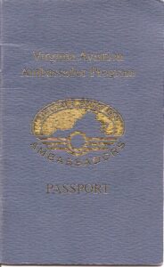
 Our curiosity aroused, we asked her what she meant, and she proceeded to give a thumbnail sketch of the Virginia Aviation Ambassadors program, and produced a passport book for the program. As she explained, we would fly to each of the airports in Virginia and collect a stamp in the little passport book which had a block for each airport. After visiting each of the 66 airports, four aviation related museums, an aviation safety seminar and the Virginia Regional Festival of Flight (the Fly-In at Suffolk) we would be eligible to receive leather flight jackets embroidered with our names. That sounded like fun, so we asked her for a passport book and our first stamp, Norfolk International Airport.
We didn’t do much stamp collecting right away. Although we flew here and there, we didn’t put much effort into making sure we had our books ready to go. We got stamps from our local destinations, SFQ, PVG and FKN but not much more for a while. I had not completed my flight training, so Dick did most of the flying. Every now and then, we would remember and bring out the book to get a stamp. First Emporia (EMV) and then Mecklenburg (AVC). Then Tangier Island (TGI), then Williamsburg (JGG). Then we started planning outings to go new places as we started to get into the spirit of the program. Even Dick’s flight instructor and flying partner, Jerry began to get into it.
I got my private pilot’s certificate in August 2013, and then we started going more places where we could share the flying and navigating. We really got into the spirit and planned some longer trips, hitting 3 or 4 or 5 airports in a day. Lawrenceville (LVL), Lake Country (W63), Tuck (W78), Danville (DAN), Campbell-Brookneal (0V4), Crewe (W81) and Blackstone (BKT). Chase City (CXE), Farmville (FVX), Lunenburg (W31). Then a sprint out to Smith Mountain Lake (W91) and back. Accomack (MFV), Tangier Island (TGI) again, and Hummel (W75). Gradually, we whittled down the airports east of the mountains and had some planning to do to get to the western part of the state. We dragged out the charts and started hatching a plan. Meanwhile, I was building hours as we went to all the other airports, getting better prepared and seasoned to make a long trip like the one we were contemplating.
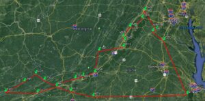
Our plan was bold. At least for us it was bold. We would leave Suffolk (SFQ) and head immediately west to Martinsville (MTV). From there we would begin a long trek to the southwestern point of the state, hitting every airport in between, and then make our way back to the northeast to end the first day in Roanoke. That meant we would visit eleven airports in one day: Martinsville (MTV), Twin Counties (HLX), Mountain Empire (MKJ), Virginia Highlands (VJI), Lee County (0VG), Lonesome Pine (LNP), Grundy (GDY), Tazwell (JFZ), New River (PSK), VA Tech (BCB) and Roanoke (ROA). The second day would be nearly as ambitious. We would depart Roanoke and visit eleven more: Ingalls (HSP), Eagles Nest (W13), Shenandoah (SHD), Bridgewater (VBW), New Market (8W2), Luray Caverns (LUA), Front Royal (FRR), Winchester (OKV), Warrenton (HWY), Culpeper (CJR), Shannon (EZF) and back to Suffolk from there. We figured about 6 hours of Hobbes time each day. Looked good on paper, but could we do it?
We started getting things together, planning in earnest. We researched the Aviation Ambassador program online, reading the notes for each airport to make sure we knew where the stamp was, who the manager was and what numbers to call if we needed assistance. We made a set of notecards for ourselves with all that information, as well as another set with kneeboard type information: a sketch of the runways with notes on length and width, right or left traffic, weather and CTAF frequencies, elevation and pattern altitude. We researched the AF/D for each. We reviewed the Virginia Airport Directory and studied the photos and notes there. And we used Google Earth to get a better perspective on the terrain and obstacles we might encounter. Finally, we each had ForeFlight on our iPads and had the entire trip planned out, noting all details we could that might helps us.
And then we waited.
We needed a weekend when the state-wide weather would be good VFR flying and when we were both available. We thought we would probably have such a weekend during the late fall, winter or even spring before the summer convective weather started. The calendar pages began to flip by, fall leaving us without an opportunity, then winter, then into spring and still no convergence of weather and crew availability. We re-studied our plans, went over our notes, came up with alternatives like sprinting out to visit a few of the more accessible airports to shorten the trip, but never managed to do that either. Then Memorial Day came, indicating that summer was about to begin and the weather would probably not favor us over such a large area. We attended the Suffolk Fly-In and got our stamp there, deciding that we would probably have to wait for fall before we got a break for the trip.
Then, Hurricane Arthur approached the coast, arriving the night of 3 July. As the storm blew out on 4th of July morning, we felt a cooling break in the humidity as the sun emerged. It was still a little breezy, but the forecast was for severe clear and winds less than 5 knots all over the state for the next three days! We each checked with our wives as to our availability for the trip, and receiving their blessings for a safe and successful trip, we agreed to meet at 0800 on 5 July, flight bags and toothbrushes packed, with a spare pair of drawers, just in case.
